Casper
Well-known member
- Apr 28, 2013
- 1,716
- 215
- Country
- USA
- Bulldog(s) Names
- "The Stallone Bros"
Seems like since 2005, and after Hurricane Katrina, we in Louisiana have been on the Naughty list. Living in Louisiana from 1976 to present, Until 2005, we really never knew what a hurricane really could be like. I mean everyone has their catastrophes, From Wild Fires, Blizzards, Earthquakes, Tornadoes, to Tsunamis right?
The Hurricane to us is a double edged sword….. If the wind doesn't get you, the water will. Hurricane Camille came into Mississippi Gulf coast, The year I was born. The winds tilting the anemometer at roughly 200 mph. The same speed roughly as a tornado, with a 29 mile wide cone! We in New Orleans didn't get the winds, but the counter clockwise rotation of the storm pushed all the water up into the lake, and low lying areas, Flooding much of the area, and when I say flooding, its not ankle deep flooding, it's more like 13 feet of water rushing through your home flooding[FONT=arial, sans-serif]….. The only survivors to this is usually aquarium fish.
Tropical storm Karen formed in the gulf, and we've been watching it closely, because it was set to brush the mouth of the Mississippi River in its path to strike in Mobile AL area. It was forecast by meteorologist, that Karen was pushing a 14' wall of water out in front of the storm, Known as Storm Surge. No matter that the storm was set to strike Mobile, The counter clockwise rotation of storm sure was to push 14 feet of water up into Lake Pontchartrain. This is a picture of my backyard,
[/FONT]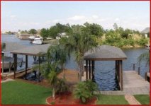
Which is directly on Lake Pontchartrain. No matter whether the winds are 45 mph, or 200 mph, the wall of water which pushes ahead of the storm, by the wind, still comes in like a tsunami. Anyway, The upper winds in the Gulf sheered off the top of the storm, causing it to blow apart. So far storm surge coming in has been about 3 foot. Katrina pushed in a 21 foot tsunami, which submerged our homes in 13 feet of water, So far with Karen, we've just suffered some over topping of the sea wall. From 1964 to 2005, we didn't know what a storm was really, in our area, and since 2005, we've been catching at least one a year. The winds really aren't bad, I basically compare the winds to that of the West coast Santa Ana winds, most of the time, although, tree branches rake the power lines, and we get the inconvenience of power outages, accompanied by very hard bands of rain, Usually until the winds die down, The power companies won't send, line men up to fix outages. Most of Louisiana, and Mississippi, is known as low-lying, or swamp areas, the same as my yard, knowing if I lived on the beach, it would be beachfront, either way, it's considered flood prone, because of tidal surge, and storm surge. The point to all this, was to explain the winds aren't necessarily the edge of a storm we worry about, the surge spreads out far the center, causing anything on the west side to be known as flood area, and anything on the north east corner of the Hurricane to be in the danger zone, prone to tornadoes, high winds, and rain from 2" to 20"s in an hour. Amazingly, The cold front, which recently visited Jeannie in Colorado, is pushing its way through our area now, and the cold air is pushing the tropical air out of our area, and thats what sheered off the head of this storm before it could turn bad. Awesome, how all this works, and how the snow front from Wyoming, Colorado thats been on our news, was the culprit in killing a killer storm before it could develop. At least we dodged this bullet for now, Definitely looking foreword to many more cold front sweeping through, to cool the Gulf of Mexico waters down, which feed these big hurricanes!!
The Hurricane to us is a double edged sword….. If the wind doesn't get you, the water will. Hurricane Camille came into Mississippi Gulf coast, The year I was born. The winds tilting the anemometer at roughly 200 mph. The same speed roughly as a tornado, with a 29 mile wide cone! We in New Orleans didn't get the winds, but the counter clockwise rotation of the storm pushed all the water up into the lake, and low lying areas, Flooding much of the area, and when I say flooding, its not ankle deep flooding, it's more like 13 feet of water rushing through your home flooding[FONT=arial, sans-serif]….. The only survivors to this is usually aquarium fish.
Tropical storm Karen formed in the gulf, and we've been watching it closely, because it was set to brush the mouth of the Mississippi River in its path to strike in Mobile AL area. It was forecast by meteorologist, that Karen was pushing a 14' wall of water out in front of the storm, Known as Storm Surge. No matter that the storm was set to strike Mobile, The counter clockwise rotation of storm sure was to push 14 feet of water up into Lake Pontchartrain. This is a picture of my backyard,
[/FONT]

Which is directly on Lake Pontchartrain. No matter whether the winds are 45 mph, or 200 mph, the wall of water which pushes ahead of the storm, by the wind, still comes in like a tsunami. Anyway, The upper winds in the Gulf sheered off the top of the storm, causing it to blow apart. So far storm surge coming in has been about 3 foot. Katrina pushed in a 21 foot tsunami, which submerged our homes in 13 feet of water, So far with Karen, we've just suffered some over topping of the sea wall. From 1964 to 2005, we didn't know what a storm was really, in our area, and since 2005, we've been catching at least one a year. The winds really aren't bad, I basically compare the winds to that of the West coast Santa Ana winds, most of the time, although, tree branches rake the power lines, and we get the inconvenience of power outages, accompanied by very hard bands of rain, Usually until the winds die down, The power companies won't send, line men up to fix outages. Most of Louisiana, and Mississippi, is known as low-lying, or swamp areas, the same as my yard, knowing if I lived on the beach, it would be beachfront, either way, it's considered flood prone, because of tidal surge, and storm surge. The point to all this, was to explain the winds aren't necessarily the edge of a storm we worry about, the surge spreads out far the center, causing anything on the west side to be known as flood area, and anything on the north east corner of the Hurricane to be in the danger zone, prone to tornadoes, high winds, and rain from 2" to 20"s in an hour. Amazingly, The cold front, which recently visited Jeannie in Colorado, is pushing its way through our area now, and the cold air is pushing the tropical air out of our area, and thats what sheered off the head of this storm before it could turn bad. Awesome, how all this works, and how the snow front from Wyoming, Colorado thats been on our news, was the culprit in killing a killer storm before it could develop. At least we dodged this bullet for now, Definitely looking foreword to many more cold front sweeping through, to cool the Gulf of Mexico waters down, which feed these big hurricanes!!

 Very interesting information, Dave, and a pretty clear meteorological explanation too. Glad the storm got dissipated by the cold front!
 boy that was a close one I was on the edge of my seat! So glad it didn't continue on its path of destruction... Glad you're safe
  I would have been scared to death. Just glad you and the boys are safe.
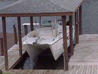


 Really nice!!!


